In October 2006 we cycled around Sikkim (India) and Bhutan. This page contains background info about our Bhutan tour. We cycled from Paro in the west of Bhutan to Luentshe in the east of the country. The trip took two weeks to complete.
Map of Bhutan with our route from Paro to Luentshe Large map
Paro - Thimpu
55 km The first 23 km from Paro to the junction with the main Puentscholing to Thimpu highway are almost entirely flat. The road is narrow but in a good condition. The remaining 30 km to Thimpu also do not have any major ascents or descents. During our visit this part of the road was closed on certain hours of the day because of major road works: a 10 year project to widen to entire highway from Thimpu to the Indian border.
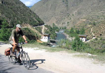
The Paro to Thimpu road
A few km's before Thimpu you can either take the 4 lane express way or the old road higher on the eastern slopes of the valley. Thimpu is a city without any traffic lights; it's easy to bike around.
Thimpu - Punakha
70 km Leave Thimpu in southern direction using the old narrow road on the eastern side of the valley. At a junction with a giant prayer wheel turn right to start the climb to Dochu La at 3055 m. The road is relatively wide and in good condition. The 23 km climb to the top is gentle.
On the pass you can see, weather permitting, the snow covered peaks of the Himalayas in the far distance. A kilometre or so below the top is nice restaurant.
It's a 45 km downhill all the way to the junction (not signposted) to the Punakha valley. The first 15 km are rough. There are no views and few villages until you get to the valley.
Punakha - Trongsa
120 km The Punakha junction is only 3 km away from Wangdi. The road is wide and good. Cross a bridge an climb steeply to Trongsa village. The first km's beyond Trongsa are almost flat but after the Kichu Resort hotel the climb starts. The top of Pele La (3300 m) is 50 km away and the climb is more difficult than the one to Dochu La. The road is narrow but good, with some steep parts.
Yaks near Pele La
A white chorten and numerous prayer flags mark the top. The landscape is alpine with dwarf bamboo and a chance of seeing yaks grazing along the road.
Prayer flags and bicycle at Pele La
The first 30 km to Chendedji Stupa (an excellent lunch spot) offer a great downhill ride. Two hundred m beyond the stupa is an expensive tourist style restaurant. The first section of the remaining 35 km to Trongsa has some minor climbs. Followed by a 20 km descent to a viewpoint opposite the impressive Trongsa Dzong. From the viewpoint (worth a stop) it's 10 km downhill to a bridge and approx. another 5 uphill to Trongsa town. Trongsa is situated at an elevation of approx. 2000 m.
The Nepal style Chendedji stupa is worth a stop
Trongsa - Jakar
75 km The first 30 km climb steadily to the top of another pass. Followed by almost 25 km of descent to a rural valley. You'll cycle along small villages with traditional farmhouses.
At the end of the Valley is a minor climb of 4 km to Kiki La. At the village of Chimney a new (shortcut) road to Ura is under construction.
The rest is again downhill or almost flat along a river to the town of Jakar.
Jakar - Ura
50 km Ura is in a valley but you'll have to climb 40 km's to reach the top of the mountains that surround it. Of which the first 30 are relatively easy to cycle.
Looking back on the climb to Ura
The climb is similar to the ascent to Dochu La. There is a false summit a few km before the real pass at 3250 m. We had cold weather here with a beginning of snow.
First snow at Ura Valley
Tip: Be sure to carry cold and wet weather clothing with you, and not in your support vehicle as weather here can change rapidly.
Ura is an interesting traditional village. Most tourists visit it on a day tour from Jakar. The new Arya Zamla Resort on the main road is highly recommended: excellent food and friendly people!
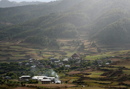
View of Ura
Ura - Mongar
This part starts with the climb to Trumsing La the highest point on the east west highway. You'll reach an altitude of 3750 m. The distance, from Ura to the top is approx. 35 km. The road is in good condition and only the last 8 km or so are steep.
Heavy snow on the top of Thrumsing La
From the top it's a very long downhill to a final altitude of only 600 m. Halfway is the village of Sengor, that has at least two places offering "fooding & lodging". The roads continues to descend to a river and finally a bridge. From there it's another 24 km, and 1000 m higher, to the town of Mongar.
Mongar - Luentshe
75 km We visited Luentshe on a day trip. We cycled there but returned by car to Mongar. The trip starts with a nice 12 km descent from Mongar to the junction. The turn-off to L. is signposted and most of the road it is in good condition. The descent continues for another 14 km to the river.
...towering cliffs on
both sides of the valley
The scenery is beautiful and very rural with towering cliffs at both sides of the valley. There are several small villages and almost no traffic. At 45 km from M. there is a steep section with hairpins. The final 5 km to Luentshe are again steep. This is the end of the road.
The road to L. makes an interesting and highly recommended side trip.
Back to Paro
We traveled back to Paro by car all the way. When you have enough time you could cycle back along the same east west road. In the future the border at Sandruk Jongkar may open (again) and you could even continue by bicycle into the Indian state of Assam. At this moment the security situation doesn't allow such a trip.
Punaka Dzong
Any questions left?
If you still have some questions left do not hesitate to contact us. Be sure to check out the FAQ pages first.